Projects
Recent and Current Projects
- Fire behaviour analysis and strategic planning for East Gippsland fires, 2014
- Tailored fuel management for One Tree Hill for the Pink Tailed Worm Lizard (DELWP, Victoria)
- South Eastern Red Tailed Black Cockatoo Phoenix and Woodstock simulations (DELWP, Victoria)
- Fire behaviour analysis expertise in litigation
- Scenario development for Barwon Otway Bushfire Risk Landscape using Woodstock (DELWP, Victoria)
- Development and delivery of training packages for Woodstock
- Fuel hazard assessment and fuel accumulation characterisation
- Database development and risk analysis for South West Bushfire Risk Landscape
- Preparation of Woodstock Models for East Central Bushfire Risk Landscape (2015 and 2018/19)
- Preparation of Victorian State-wide datasets for Woodstock Modelling
- GIS validation of Orange Bellied Parrot records
- Retrospective mapping and validation of Mallee fires using LANDSAT and digital imagery
- Training DELWP staff in using Sentinel and Landsat for fire mapping
- Risk assessment using Phoenix Rapidfire for Latrobe City Shire
- Development of revised plantation fuel types for use in Phoenix Rapidfire
- Mapping of and validation plantation fuel types
- Risk Assessment for Hancock Victorian Plantations and Forest Owners Conference
- Preparation of scenarios and other material for the Community Bushfire Connection exercise (Gippsland 2017)
- Preparation of Bicentennial National Trail Guidebook 12 (Tom Groggin to Healesville, 2018)
- Detailed risk analysis and strategy evaluation of the ACT Regional Fire Management Plan (2019)
- Expert knowledge and dataset development for a model of tree stem age by the Ecological Analysis & Synthesis team at Arthur Rylah Institute (DELWP Victoria)
Previous Projects at DEPI
- Victorian Bushfire Risk Profiles
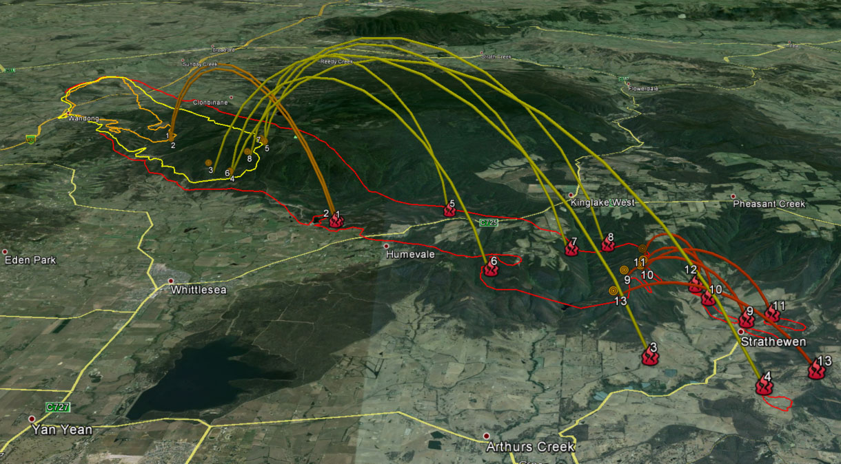
- Reconstruction of Black Saturday Bushfires
- Future Fire Project – Otway Pilot
- Extensive modelling of timber and water management options and influence of climate change in Melbourne’s catchments
- Fire Risk Analysis for proposed housing developments
- Preparation of Google Earth reconstructions for the Bushfires Royal Commission